
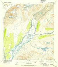
1952 Map of Healy B-1
USGS Topo · Published 1953About this map
Susitna Glacier and the West Fork Glacier dominate the northern terrain of this mid-century survey, acting as the primary hydrologic sources for the glacial drainage systems that define the region. The landscape is shaped by the massive outwash of the Susitna River, which flows southwest from the ice fields, collecting tributaries such as the East Fork and Boulder Creek. This 1952 study, based on 1949 aerial photography, documents the braided river channels and the intricate contour patterns of the high-altitude topography within the Alaska-Third Judicial Division. The map reveals a wild, unpopulated environment focused on the natural flow of water and ice, where the West Fork joins the larger Susitna system amidst a complex network of glacial moraines and rocky elevations.
Find a feature on this map
6 named features on this map. Tap any name to fly to it.
Don’t see what you’re looking for? This feature index may not catch every label — zoom into the map to look around manually.
Map Details
Editions of this 1952 Healy B-1 Map
2 editions found
Other maps of this area

1949 · Healy B-2
USGS Topo · 1:63,360

1949 · Healy A-1
USGS Topo · 1:63,360

1950 · Mount Hayes
USGS Topo · 1:250,000

1950 · Healy B-1
USGS Topo · 1:63,360

1950 · Mount Hayes A-6
USGS Topo · 1:63,360

1951 · Healy
USGS Topo · 1:250,000

1951 · Mount Hayes
USGS Topo · 1:250,000

1951 · Mount Hayes B-6
USGS Topo · 1:63,360

1951 · Healy C-1
USGS Topo · 1:63,360

1951 · Healy C-2
USGS Topo · 1:63,360