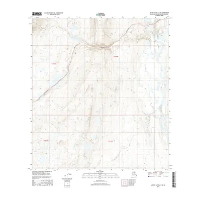
2016 Map of Mount Hayes A-6 SE
USGS Topo · Published 2016About this map
Crazy Notch serves as a prominent geological landmark in this high-altitude Alaskan landscape, where the narrow passage cuts through the rising terrain of the eastern Alaska Range. This 2016 survey illustrates a largely untouched wilderness within the Matanuska-Susitna Borough, defined by the glacial outwash and braided channels of the Maclaren River flowing through the eastern edge of the quadrangle. Human presence is limited to the gravel path of the Denali Highway, which winds through the northwestern corner and past the notch, providing one of the few terrestrial access points to this subarctic region. The map captures the intricate hydrology of the area, featuring numerous small alpine lakes and wetlands that dominate the T21S and T22S townships, reflecting a terrain shaped by permafrost and seasonal meltwater.
Find a feature on this map
7 named features on this map. Tap any name to fly to it.
Don’t see what you’re looking for? This feature index may not catch every label — zoom into the map to look around manually.
Map Details
Editions of this 2016 Mount Hayes A-6 SE Map
This is the sole edition of this map. No revisions or reprints were ever made.
Other maps of this area

1949 · Mount Hayes A-5
USGS Topo · 1:63,360

1950 · Mount Hayes
USGS Topo · 1:250,000

1950 · Mount Hayes A-6
USGS Topo · 1:63,360

1951 · Gulkana
USGS Topo · 1:250,000

1951 · Mount Hayes
USGS Topo · 1:250,000

1951 · Gulkana D-6
USGS Topo · 1:63,360

1951 · Gulkana D-5
USGS Topo · 1:63,360
1952 · Gulkana D-6
USGS Topo · 1:63,360
1952 · Gulkana D-5
USGS Topo · 1:63,360

1952 · Mount Hayes A-6
USGS Topo · 1:63,360