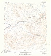
1952 Map of Gulkana D-6
USGS Topo · Published 1953About this map
The Maclaren River cuts a complex path through this high-elevation landscape, which was mapped by the Geological Survey during the early 1950s using aerial photography. This territory is characterized by its significant vertical relief, marked by several Triangulation Bench Marks that serve as primary navigation points for surveyors and travelers alike. Notable peaks include VABM 5275 Laren in the southwest and VABM 4797 Round to the north. Evidence of human presence is limited to a remote Cabin along the riverbank, indicating the sparse, seasonal nature of habitation in this region at the time. The drainage system is further defined by Clearwater Creek and Moose Creek, which feed into the primary river valley amidst a network of smaller ponds and glacial features.
Find a feature on this map
8 named features on this map. Tap any name to fly to it.
Don’t see what you’re looking for? This feature index may not catch every label — zoom into the map to look around manually.
Map Details
Editions of this 1952 Gulkana D-6 Map
2 editions found
Other maps of this area

1949 · Healy A-1
USGS Topo · 1:63,360

1949 · Mount Hayes A-5
USGS Topo · 1:63,360

1950 · Talkeetna Mountains
USGS Topo · 1:250,000

1950 · Mount Hayes
USGS Topo · 1:250,000

1950 · Mount Hayes A-6
USGS Topo · 1:63,360

1951 · Healy
USGS Topo · 1:250,000

1951 · Gulkana
USGS Topo · 1:250,000

1951 · Mount Hayes
USGS Topo · 1:250,000

1951 · Gulkana D-6
USGS Topo · 1:63,360

1951 · Gulkana D-5
USGS Topo · 1:63,360