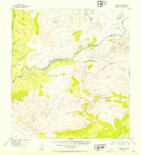
1952 Map of Gulkana D-6
USGS Topo · Published 1953About this map
The Maclaren River cuts a wide, braided path through this interior Alaskan wilderness, recorded during a 1952 survey by the Geological Survey. The landscape is dominated by high-elevation peaks, most notably the towering VABM 5276 Laren and VABM 4797 Around, which define the drainage basins for northern flowing waters like Clearwater Creek. Settlement is nearly non-existent in this era, represented only by a solitary Cabin located along the riverbank, serving as a rare human landmark in a region of glacial-fed streams and complex topography. To the southeast, Moose Creek meanders through lower elevations, providing a stark contrast to the high ridges of VABM 4224 Horn. This map serves as a primary record of the terrain before modern access, based on 1950 aerial photography and multiplex mapping methods.
Find a feature on this map
9 named features on this map. Tap any name to fly to it.
Don’t see what you’re looking for? This feature index may not catch every label — zoom into the map to look around manually.
Map Details
Editions of this 1952 Gulkana D-6 Map
2 editions found
Other maps of this area

1949 · Healy A-1
USGS Topo · 1:63,360

1949 · Mount Hayes A-5
USGS Topo · 1:63,360

1950 · Talkeetna Mountains
USGS Topo · 1:250,000

1950 · Mount Hayes
USGS Topo · 1:250,000

1950 · Mount Hayes A-6
USGS Topo · 1:63,360

1951 · Healy
USGS Topo · 1:250,000

1951 · Gulkana
USGS Topo · 1:250,000

1951 · Mount Hayes
USGS Topo · 1:250,000

1951 · Gulkana D-6
USGS Topo · 1:63,360

1951 · Gulkana D-5
USGS Topo · 1:63,360