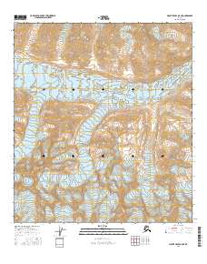
2016 Map of Mount Hayes B-5 NE
USGS Topo · Published 2016About this map
Black Rapids Glacier dominates the northern reaches of this high-latitude terrain, where the ice and its surrounding glacial features stretch across the high interior landscape. This 2016 survey captures the topographic complexity of the Eastern Alaska Range, where elevation contours reveal steep gradients and the remnants of massive ice movements. The map is organized by the Public Land Survey System, showing the intersection of several townships including t16s r8e, t17s r8e, and t18s r9e. The absence of man-made structures or settlements highlights the isolation of this alpine environment, focusing instead on the dramatic natural elevation changes and the massive footprint of the glacier itself.
Find a feature on this map
8 named features on this map. Tap any name to fly to it.
Don’t see what you’re looking for? This feature index may not catch every label — zoom into the map to look around manually.
Map Details
Editions of this 2016 Mount Hayes B-5 NE Map
This is the sole edition of this map. No revisions or reprints were ever made.
Other maps of this area

1950 · Mount Hayes
USGS Topo · 1:250,000

1950 · Mount Hayes C-4
USGS Topo · 1:63,360

1951 · Mount Hayes
USGS Topo · 1:250,000

1951 · Mount Hayes C-5
USGS Topo · 1:63,360

1951 · Mt. Hayes B-5
USGS Topo · 1:63,360

1952 · Mount Hayes C-4
USGS Topo · 1:63,360

1952 · Mount Hayes B-4
USGS Topo · 1:63,360

1954 · Mount Hayes B-4
USGS Topo · 1:63,360

1955 · Mount Hayes
USGS Topo · 1:250,000
2016 · Mount Hayes C-5 SW
USGS Topo · 1:25,000