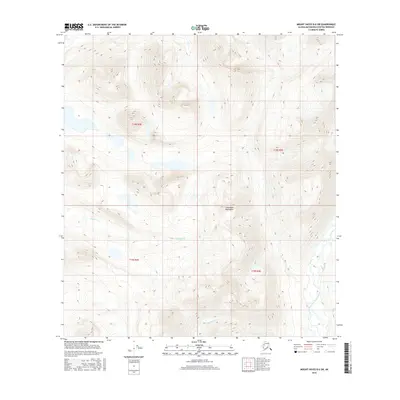
2016 Map of Mount Hayes B-6 SW
USGS Topo · Published 2016About this map
Clearwater Mountains dominate this high-altitude landscape in the Alaska interior, where the topography rises sharply across steep contour intervals. The terrain is defined by its drainage systems, with Boulder Cr and Clearwater Cr carving paths through the mountain slopes. In the southeast corner, the West Fork Maclaren River cuts through the lower elevations, marking a significant hydrologic feature for the region. This 2016 survey illustrates a largely unpopulated wilderness within the Matanuska-Susitna Borough, where land management is organized by the Public Land Survey System. The grid lines for t18s r4e, t18s r5e, t19s r4e, and t19s r5e provide the essential framework for navigating and identifying tracts in this vast subarctic environment.
Find a feature on this map
8 named features on this map. Tap any name to fly to it.
Don’t see what you’re looking for? This feature index may not catch every label — zoom into the map to look around manually.
Map Details
Editions of this 2016 Mount Hayes B-6 SW Map
This is the sole edition of this map. No revisions or reprints were ever made.
Other maps of this area

1949 · Healy A-1
USGS Topo · 1:63,360

1950 · Mount Hayes
USGS Topo · 1:250,000

1950 · Healy B-1
USGS Topo · 1:63,360

1950 · Mount Hayes A-6
USGS Topo · 1:63,360

1951 · Healy
USGS Topo · 1:250,000

1951 · Mount Hayes
USGS Topo · 1:250,000

1951 · Mount Hayes B-6
USGS Topo · 1:63,360
1952 · Healy A-1
USGS Topo · 1:63,360

1952 · Healy B-1
USGS Topo · 1:63,360

1952 · Mount Hayes A-6
USGS Topo · 1:63,360