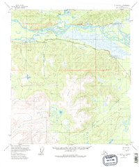
1955 Map of Mount Hayes C-1
USGS Topo · Published 1981About this map
The Tanana River dominates the northern landscape of this interior Alaskan territory, its braided channels and vast wetlands like Johnson Slough creating a complex riparian corridor. The mid-1950s infrastructure of the region is anchored by the Alaska Highway, which runs parallel to an Aboveground Pipeline and the river valley. The small settlement of Dot Lake appears as a critical hub along the highway, supported by a nearby Landing Strip and Gaging Sta.
Find a feature on this map
19 named features on this map. Tap any name to fly to it.
Don’t see what you’re looking for? This feature index may not catch every label — zoom into the map to look around manually.
Map Details
Editions of this 1955 Mount Hayes C-1 Map
4 editions found

Other maps of this area

1949 · Tanacross
USGS Topo · 1:250,000

1949 · Tanacross B-6
USGS Topo · 1:63,360

1950 · Tanacross
USGS Topo · 1:250,000

1950 · Mount Hayes
USGS Topo · 1:250,000

1951 · Mount Hayes
USGS Topo · 1:250,000

1951 · Tanacross B-6
USGS Topo · 1:63,360

1954 · Mount Hayes B-1
USGS Topo · 1:63,360

1954 · Mount Hayes D-2
USGS Topo · 1:63,360

1954 · Tanacross C-6
USGS Topo · 1:63,360

1954 · Mount Hayes D-1
USGS Topo · 1:63,360