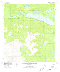
1955 Map of Mount Hayes C-1
USGS Topo · Published 1981About this map
The Alaska Highway corridor serves as the primary artery through this interior landscape, paralleled by a significant Pipeline segment noted as Aboveground. Near the eastern edge, the settlement of Dot Lake sits beside its namesake water body, supported by a nearby Landing Strip that highlights the importance of aerial transport in this road-accessible but isolated region. The northern portion is defined by the braided channels of the Tanana River and the meandering Johnson Slough, which create a complex network of wetlands and shifting waterways. South of the river, the terrain rises toward the prominent Knob Ridge, interspersed with numerous high-altitude lakes such as Fish Lake and Plateau Lake. This survey captures the infrastructure of the mid-20th century, from the Gaging Sta on Sam Creek to the industrial presence of a Gravel Pit along the highway.
Find a feature on this map
22 named features on this map. Tap any name to fly to it.
Don’t see what you’re looking for? This feature index may not catch every label — zoom into the map to look around manually.
Map Details
Editions of this 1955 Mount Hayes C-1 Map
4 editions found

Other maps of this area

1949 · Tanacross
USGS Topo · 1:250,000

1949 · Tanacross B-6
USGS Topo · 1:63,360

1950 · Tanacross
USGS Topo · 1:250,000

1950 · Mount Hayes
USGS Topo · 1:250,000

1951 · Mount Hayes
USGS Topo · 1:250,000

1951 · Tanacross B-6
USGS Topo · 1:63,360

1954 · Mount Hayes B-1
USGS Topo · 1:63,360

1954 · Mount Hayes D-2
USGS Topo · 1:63,360

1954 · Tanacross C-6
USGS Topo · 1:63,360

1954 · Mount Hayes D-1
USGS Topo · 1:63,360