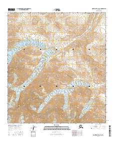
2016 Map of Mount Hayes C-5 SE
USGS Topo · Published 2016About this map
The high peaks of the Alaska Range dominate this 2016 survey, where the massive McGinnis Glacier flows through the central terrain. This landscape is defined by extreme elevation changes, with the summit of Mt Pillsbury standing as a primary landmark in the northeastern portion of the sheet. The map details the intricate glacial drainage patterns and mountain topography of Southeast Fairbanks, illustrating the intersection of major township boundaries including t15s r8e and t16s r9e. It offers a precise view of the ice and rock formations as they existed in the early 21st century, providing a baseline for studying high-altitude Alaskan environments.
Find a feature on this map
7 named features on this map. Tap any name to fly to it.
Don’t see what you’re looking for? This feature index may not catch every label — zoom into the map to look around manually.
Map Details
Editions of this 2016 Mount Hayes C-5 SE Map
This is the sole edition of this map. No revisions or reprints were ever made.
Other maps of this area

1950 · Mount Hayes
USGS Topo · 1:250,000

1950 · Mount Hayes C-4
USGS Topo · 1:63,360

1951 · Mount Hayes
USGS Topo · 1:250,000

1951 · Mount Hayes C-5
USGS Topo · 1:63,360

1951 · Mt. Hayes B-5
USGS Topo · 1:63,360

1952 · Mount Hayes C-4
USGS Topo · 1:63,360

1952 · Mount Hayes B-4
USGS Topo · 1:63,360

1954 · Mount Hayes B-4
USGS Topo · 1:63,360

1955 · Mount Hayes
USGS Topo · 1:250,000
2016 · Mount Hayes C-5 NE
USGS Topo · 1:25,000