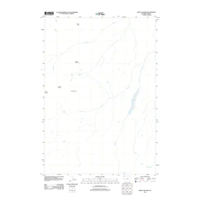
2012 Map of Mount Holmes
USGS Topo · Published 2012About this map
Mount Holmes and the surrounding high-altitude terrain dominate this 2012 survey of northwest Park County. The landscape is defined by a series of prominent summits including Dome Mountain, Antler Peak, and Trilobite Point, which serve as the headwaters for several drainage systems. These include the northward-flowing Indian Cr and the winding course of Winter Cr, which feeds into the elongated Grizzly Lake. A hydrothermal element is present near the western edge with the Riverside Geyser, while Straight Cr and Obsidian Cr define the lower elevations. The map reveals a wilderness environment devoid of modern infrastructure, where the natural hydrology and topographical relief dictate the movement of water and potential trails. This data provides a clear record of the area's geological features, from the White Peaks to the subtle marshes and seasonal streams that characterize the high country.
Find a feature on this map
11 named features on this map. Tap any name to fly to it.
Don’t see what you’re looking for? This feature index may not catch every label — zoom into the map to look around manually.
Map Details
Editions of this 2012 Mount Holmes Map
This is the sole edition of this map. No revisions or reprints were ever made.
Other maps of this area

1885 · Gallatin
USGS Topo · 1:125,000

1885 · Gallatin
USGS Topo · 1:125,000

1901 · Gallatin
USGS Topo · 1:125,000

1908 · Gallatin
USGS Topo · 1:125,000

1911 · Gallatin
USGS Topo · 1:125,000

1955 · Ashton
USGS Topo · 1:250,000

1958 · Ashton
USGS Topo · 1:250,000

1958 · Madison Junction
USGS Topo · 1:62,500

1958 · Mount Holmes
USGS Topo · 1:62,500
1958 · Norris Junction
USGS Topo · 1:62,500