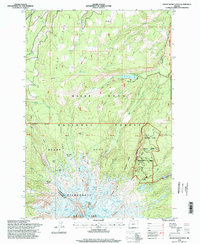
1996 Map of Mount Hood North
USGS Topo · Published 1998About this map
The northern slopes of Mount Hood dominate this topographic study, reaching from the glaciated peaks down to the vital water resources of the Middle Fork Hood River valley. High-altitude landmarks like the Cloud Cap Inn and Tilly Jane Guard Station are situated within a designated Historic Area, while the lower elevations show the industrial presence of the Dollar Quarry and Clear Creek Quarry. The landscape is defined by the convergence of major glacial flows, including the Ladd Glacier and Sandy Glacier, which feed the many branches of the river system. A significant engineering feature is the Clear Branch Dam, which created Laurance Lake to manage the runoff from the Clear Branch. Recreation and conservation are evident through the Mount Hood Wilderness boundary, marking the transition from the Mount Hood National Forest into the high alpine basins of Elk Cove and Eden Park.
Find a feature on this map
68 named features on this map. Tap any name to fly to it.
Don’t see what you’re looking for? This feature index may not catch every label — zoom into the map to look around manually.
Map Details
Editions of this 1996 Mount Hood North Map
2 editions found
Other maps of this area

1924 · Mount Hood
USGS Topo · 1:125,000

1926 · Hood River
USGS Topo · 1:125,000

1927 · Mount Hood
USGS Topo · 1:125,000

1929 · Hood River
USGS Topo · 1:125,000

1953 · The Dalles
USGS Topo · 1:250,000

1956 · The Dalles
USGS Topo · 1:250,000

1957 · The Dalles
USGS Topo · 1:250,000

1957 · Bonneville Dam
USGS Topo · 1:62,500

1957 · Hood River
USGS Topo · 1:62,500

1962 · Cathedral Ridge
USGS Topo · 1:24,000