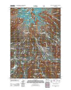
2011 Map of Mount Hood South
USGS Topo · Published 2011About this map
Mount Hood dominates this landscape, its glacial features like Reid Glacier and Zigzag Glacier giving way to a network of alpine lodges and historic crossings. This 2011 survey illustrates the high-altitude infrastructure of Clackamas County, from the iconic Timberline Lodge and its dedicated Post Office to the remote Silcox Hut. The map traces the transition from the volcanic peaks at Crater Rock and Steel Cliff down to the mountain's recreational and historical sites. Notable human history is anchored at Summit Meadows, where the Summit Meadows Cemetery sits near the historic route of the East Fork Salmon River. Further south, the map details the passage through Barlow Pass and Bennett Pass, reflecting the enduring paths used to traverse the Cascades. Water resources are prominent, including the Trillium Lake Dam and the headwaters of the Sandy River.
Find a feature on this map
78 named features on this map. Tap any name to fly to it.
Don’t see what you’re looking for? This feature index may not catch every label — zoom into the map to look around manually.
Map Details
Editions of this 2011 Mount Hood South Map
This is the sole edition of this map. No revisions or reprints were ever made.
Other maps of this area

1924 · Mount Hood
USGS Topo · 1:125,000

1927 · Mount Hood
USGS Topo · 1:125,000

1953 · The Dalles
USGS Topo · 1:250,000

1956 · The Dalles
USGS Topo · 1:250,000

1956 · High Rock
USGS Topo · 1:62,500

1956 · Mt. Wilson
USGS Topo · 1:62,500

1957 · The Dalles
USGS Topo · 1:250,000

1962 · Cathedral Ridge
USGS Topo · 1:24,000
1962 · Badger Lake
USGS Topo · 1:24,000
1962 · Government Camp
USGS Topo · 1:24,000