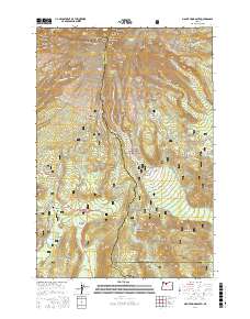
2017 Map of Mount Hood South
USGS Topo · Published 2017About this map
The southern slopes of Mt Hood dominate this study of Mount Hood National Forest, where high-elevation glaciers and steep ridges give way to the historic corridor of the Barlow Rd. The settlement at Government Camp serves as a central hub, surrounded by a landscape defined by volcanic geology and alpine hydrology. Features like the White River Glacier and Zigzag Glacier feed the headwaters of the Zigzag River and Salmon River, while the Pacific Crest National Scenic Trail winds through the central terrain.
Find a feature on this map
87 named features on this map. Tap any name to fly to it.
Don’t see what you’re looking for? This feature index may not catch every label — zoom into the map to look around manually.
Map Details
Editions of this 2017 Mount Hood South Map
This is the sole edition of this map. No revisions or reprints were ever made.
Other maps of this area

1924 · Mount Hood
USGS Topo · 1:125,000

1927 · Mount Hood
USGS Topo · 1:125,000

1953 · The Dalles
USGS Topo · 1:250,000

1956 · The Dalles
USGS Topo · 1:250,000

1956 · High Rock
USGS Topo · 1:62,500

1956 · Mt. Wilson
USGS Topo · 1:62,500

1957 · The Dalles
USGS Topo · 1:250,000

1962 · Cathedral Ridge
USGS Topo · 1:24,000
1962 · Badger Lake
USGS Topo · 1:24,000
1962 · Government Camp
USGS Topo · 1:24,000