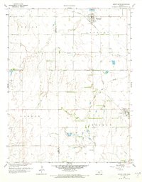
1959 Map of Mount Hope
USGS Topo · Published 1973About this map
The agrarian landscape of northwest Sedgwick County is defined by the Missouri Pacific railroad corridor, which links the established agricultural centers of Mount Hope and Andale during the late 1950s. The terrain is notably etched by the winding course of the Big Slough and its South Fork, creating a distinct drainage pattern across the townships of Greeley and Sherman. One of the most significant historical markers shown is the Old Indian Boundary, which cuts across the southern portion of the map, providing a glimpse into the earlier division of the Kansas territory.
Find a feature on this map
18 named features on this map. Tap any name to fly to it.
Don’t see what you’re looking for? This feature index may not catch every label — zoom into the map to look around manually.
Map Details
Editions of this 1959 Mount Hope Map
2 editions found
Other maps of this area

1889 · Cheney
USGS Topo · 1:125,000

1891 · Cheney
USGS Topo · 1:125,000

1901 · Cheney
USGS Topo · 1:125,000

1955 · Wichita
USGS Topo · 1:250,000

1958 · Wichita
USGS Topo · 1:250,000

1958 · Patterson
USGS Topo · 1:24,000
1958 · Bentley
USGS Topo · 1:24,000
1958 · Colwich
USGS Topo · 1:24,000

1959 · Mount Hope
USGS Topo · 1:24,000
1961 · Haven
USGS Topo · 1:24,000