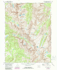
1970 Map of Mount Jackson
USGS Topo · Published 1988About this map
The high-altitude drainage systems of White River National Forest dominate this 1970s survey, showing a landscape of extreme elevations and glacially carved basins. The topography is defined by the Holy Cross Ridge and prominent summits including Mount Jackson, Eagle Peak, and Savage Peak. This environment supported seasonal mining and recreation, as evidenced by the Prospect situated on the slopes of Middle Mountain and the Lake Charles Trail leading toward the interior basins. Water is a defining element of the area, with numerous high-country reservoirs and natural bodies like Mystic Island Lake, Fairview Lake, and Treasure Vault Lake feeding into East Lake Creek and Cross Creek. The presence of Tellurium Park and Tellurium Creek suggests a history of mineral exploration in the late nineteenth and early twentieth centuries, as prospectors sought telluride ores in these difficult-to-reach subalpine zones.
Find a feature on this map
50 named features on this map. Tap any name to fly to it.
Don’t see what you’re looking for? This feature index may not catch every label — zoom into the map to look around manually.
Map Details
Editions of this 1970 Mount Jackson Map
3 editions found
Other maps of this area

1889 · Leadville
USGS Topo · 1:125,000

1891 · Leadville
USGS Topo · 1:125,000

1909 · Mount Jackson
USGS Topo · 1:125,000

1911 · Mount Jackson
USGS Topo · 1:125,000

1934 · Minturn
USGS Topo · 1:62,500

1942 · Leadville
USGS Topo · 1:125,000

1949 · Holy Cross
USGS Topo · 1:62,500

1950 · Minturn
USGS Topo · 1:62,500

1951 · Holy Cross
USGS Topo · 1:62,500

1957 · Leadville
USGS Topo · 1:250,000