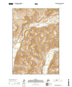
2019 Map of Mount Katmai A-3 NW
USGS Topo · Published 2019About this map
Katmai National Park encompasses this entire stretch of the Alaska Peninsula, a landscape defined by volcanic geology and dramatic elevation changes. The Katmai River is the central hydrologic feature, carving through the Katmai Canyon before broadening into the Katmai Valley in the southwest. This area, surveyed for the 2019 edition, includes several high-altitude water bodies such as Crater Lake and the Katmai Lakes. Along the eastern edge, the Barrier Range rises sharply above Soluka Creek, while Noisy Mtn stands as a prominent landmark in the north. The map also records the location of Fulton Falls, providing a detailed look at the drainage patterns of this remote interior before they reach the Shelikof Strait.
Find a feature on this map
17 named features on this map. Tap any name to fly to it.
Don’t see what you’re looking for? This feature index may not catch every label — zoom into the map to look around manually.
Map Details
Editions of this 2019 Mount Katmai A-3 NW Map
This is the sole edition of this map. No revisions or reprints were ever made.
Other maps of this area

1948 · Mt Katmai
USGS Topo · 1:250,000

1951 · Mt Katmai
USGS Topo · 1:250,000

1951 · Mount Katmai A-3
USGS Topo · 1:63,360

1951 · Mount Katmai B-4
USGS Topo · 1:63,360

1951 · Mount Katmai A-4
USGS Topo · 1:63,360

1951 · Mount Katmai B-3
USGS Topo · 1:63,360

1964 · Mt. Katmai
USGS Topo · 1:250,000
2019 · Mount Katmai B-3 SE
USGS Topo · 1:25,000
2019 · Mount Katmai A-3 NE
USGS Topo · 1:25,000
2019 · Mount Katmai A-4 SE
USGS Topo · 1:25,000