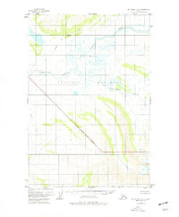
1951 Map of Mount Katmai A-6
USGS Topo · Published 1977About this map
Katmai National Monument covers a significant portion of this interior Alaskan landscape, characterized by the winding headwaters of the Alaska Peninsula. Braided river systems such as Angle Creek and Takayofo Creek dominate the topography, illustrating the drainage patterns of this glacially influenced terrain during the mid-century. Based on 1951 aerial photography, the survey delineates an National Monument Boundary (Indefinite) through an area of predominantly unsurveyed and unmarked land locations. Smaller tributaries like Contact Creek and Gertrude Creek flow through various townships, providing a clear view of the water-rich geography before later shifts in administrative boundaries or landscape evolution.
Find a feature on this map
7 named features on this map. Tap any name to fly to it.
Don’t see what you’re looking for? This feature index may not catch every label — zoom into the map to look around manually.
Map Details
Editions of this 1951 Mount Katmai A-6 Map
3 editions found
Other maps of this area

1943 · Ugashik
USGS Topo · 1:250,000

1948 · Mt Katmai
USGS Topo · 1:250,000

1948 · Ugashik
USGS Topo · 1:250,000

1949 · Ugashik
USGS Topo · 1:250,000

1951 · Mt Katmai
USGS Topo · 1:250,000

1951 · Karluk
USGS Topo · 1:250,000

1951 · Mount Katmai A-6
USGS Topo · 1:63,360

1951 · Ugashik D-1
USGS Topo · 1:63,360

1951 · Mount Katmai B-6
USGS Topo · 1:63,360

1951 · Naknek B-1
USGS Topo · 1:63,360