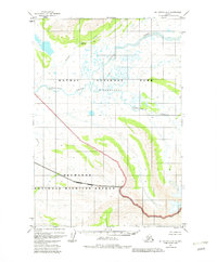
1951 Map of Mount Katmai A-6
USGS Topo · Published 1982About this map
Katmai National Park (Wilderness) and the Becharof National Wildlife Refuge converge in this remote Alaskan wilderness, documented through aerial photography from the early 1950s. The landscape is defined by its complex drainage systems, where the meandering Angle Creek and Takayofo Creek navigate a mosaic of wetlands and small water bodies. These hydrologic patterns reflect the primitive state of the Alaska Peninsula before large-scale administrative revisions in the early 1980s.
Find a feature on this map
7 named features on this map. Tap any name to fly to it.
Don’t see what you’re looking for? This feature index may not catch every label — zoom into the map to look around manually.
Map Details
Editions of this 1951 Mount Katmai A-6 Map
3 editions found
Other maps of this area

1943 · Ugashik
USGS Topo · 1:250,000

1948 · Mt Katmai
USGS Topo · 1:250,000

1948 · Ugashik
USGS Topo · 1:250,000

1949 · Ugashik
USGS Topo · 1:250,000

1951 · Mt Katmai
USGS Topo · 1:250,000

1951 · Karluk
USGS Topo · 1:250,000

1951 · Mount Katmai A-6
USGS Topo · 1:63,360

1951 · Ugashik D-1
USGS Topo · 1:63,360

1951 · Mount Katmai B-6
USGS Topo · 1:63,360

1951 · Naknek B-1
USGS Topo · 1:63,360