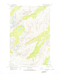
1951 Map of Mount Katmai D-2
USGS Topo · Published 1975About this map
The Mc Neil River State Game Sanctuary dominates the northern reaches of this 1951 topographic study, reflecting early conservation efforts on the Alaska Peninsula. This area is defined by its complex hydrologic network, where the Mc Neil River and Little Kamishak River carve through high-relief terrain. The map captures the region as it existed in the mid-20th century, before more modern infrastructure or designations. In the southern half, Strike Creek and the main branch of the Kamishak River illustrate the glacial-fed drainage patterns characteristic of the Kenai Peninsula Borough's western frontier. Unsurveyed land lines established by the Bureau of Land Management underscore the wild nature of this landscape, which remains largely devoid of roads or settlements during this period.
Find a feature on this map
6 named features on this map. Tap any name to fly to it.
Don’t see what you’re looking for? This feature index may not catch every label — zoom into the map to look around manually.
Map Details
Editions of this 1951 Mount Katmai D-2 Map
2 editions found
Other maps of this area

1948 · Mt Katmai
USGS Topo · 1:250,000

1951 · Mt Katmai
USGS Topo · 1:250,000

1951 · Iliamna A-5
USGS Topo · 1:63,360

1951 · Iliamna A-4
USGS Topo · 1:63,360

1951 · Mount Katmai C-3
USGS Topo · 1:63,360

1951 · Mount Katmai D-1
USGS Topo · 1:63,360

1951 · Mount Katmai C-2
USGS Topo · 1:63,360

1951 · Mount Katmai D-2
USGS Topo · 1:63,360

1951 · Mount Katmai D-3
USGS Topo · 1:63,360

1951 · Mount Katmai C-1
USGS Topo · 1:63,360