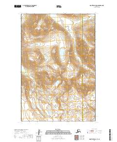
2019 Map of Mount Katmai D-3 SE
USGS Topo · Published 2019About this map
Katmai National Park preserves a vast, glacially carved landscape within the Lake and Peninsula Borough. This 2019 survey documents the complex topography of the region, where high-elevation drainage systems like Hardscrabble Cr navigate sharp relief and alpine wetlands. The map specifically captures the administrative boundary between Lake and Peninsula and the Kenai Peninsula Borough, illustrating how these political lines intersect with the natural terrain. The survey reflects a contemporary look at the park's interior, providing essential detail for understanding the hydrological patterns and elevation changes that define this protected Alaskan wilderness.
Find a feature on this map
7 named features on this map. Tap any name to fly to it.
Don’t see what you’re looking for? This feature index may not catch every label — zoom into the map to look around manually.
Map Details
Editions of this 2019 Mount Katmai D-3 SE Map
This is the sole edition of this map. No revisions or reprints were ever made.
Other maps of this area

1948 · Mt Katmai
USGS Topo · 1:250,000

1951 · Mt Katmai
USGS Topo · 1:250,000

1951 · Mount Katmai C-3
USGS Topo · 1:63,360

1951 · Mount Katmai C-2
USGS Topo · 1:63,360

1951 · Mount Katmai D-2
USGS Topo · 1:63,360

1951 · Mount Katmai D-3
USGS Topo · 1:63,360
1953 · Mount Katmai C-2
USGS Topo · 1:63,360

1964 · Mt. Katmai
USGS Topo · 1:250,000
2019 · Mount Katmai C-2 NW
USGS Topo · 1:25,000
2019 · Mount Katmai D-3 NE
USGS Topo · 1:25,000