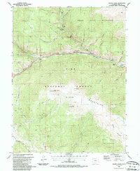
1987 Map of Mount Logan
USGS Topo · Published 1987About this map
Grant and Webster serve as the primary human anchors in this high-altitude landscape dominated by the Platte River Mountains and Kenosha Mountains. The North Fork South Platte River carves a deep valley that dictates the path of travel, evidenced by the presence of the Old Kenosha Grade and the clustering of infrastructure such as a Substation and Gaging Sta. This 1980s survey illustrates a wilderness in transition, where mining history persists through several Prospects and an Air Shaft, while the region has increasingly turned toward recreation within the Mount Evans Wilderness and Lost Creek Wilderness. From the summit of Mount Logan down to the creek beds of Frenchman Gulch and Brandywine Gulch, the map details a terrain of steep drainages and isolated settlements like Santa Maria that have long weathered the alpine environment.
Find a feature on this map
49 named features on this map. Tap any name to fly to it.
Don’t see what you’re looking for? This feature index may not catch every label — zoom into the map to look around manually.
Map Details
Editions of this 1987 Mount Logan Map
This is the sole edition of this map. No revisions or reprints were ever made.
Other maps of this area

1903 · Georgetown
USGS Topo · 1:62,500

1905 · Georgetown
USGS Topo · 1:62,500

1924 · Montezuma
USGS Topo · 1:62,500

1926 · Montezuma
USGS Topo · 1:62,500

1933 · Montezuma
USGS Topo · 1:62,500

1937 · Como
USGS Topo · 1:62,500

1945 · Shawnee
USGS Topo · 1:24,000

1945 · Mount Logan
USGS Topo · 1:24,000

1948 · Mount Logan
USGS Topo · 1:24,000

1948 · Shawnee
USGS Topo · 1:24,000