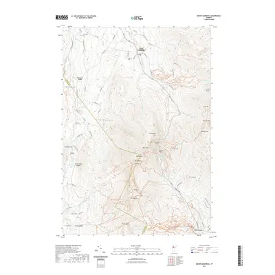
2021 Map of Mount Mansfield
USGS Topo · Published 2021About this map
Mt Mansfield dominates this 2021 topographic survey, serving as the dramatic centerpiece where the Chittenden and Lamoille county lines converge. The landscape is defined by the high peaks of the Green Mountains, including The Chin, The Nose, and The Forehead, which overlook the narrow passage of Smugglers Notch. In the valleys below, small settlements and agricultural sites like South Cambridge and Underhill Center anchor the local geography. Family history is preserved in several burial grounds scattered across the terrain, including Hopkins Cem and Valley Cem. The drainage patterns are clearly visible, with the Seymour River and Brewster River flowing from the higher elevations. This modern data illustrates the enduring placement of landmarks like Sterling Pond and Bingham Falls relative to the road networks of Pleasant Valley.
Find a feature on this map
89 named features on this map. Tap any name to fly to it.
Don’t see what you’re looking for? This feature index may not catch every label — zoom into the map to look around manually.
Map Details
Editions of this 2021 Mount Mansfield Map
This is the sole edition of this map. No revisions or reprints were ever made.
Other maps of this area

1919 · Montpelier
USGS Topo · 1:62,500

1921 · Richmond
USGS Topo · 1:48,000

1921 · Montpelier
USGS Topo · 1:62,500

1924 · Camels Hump
USGS Topo · 1:62,500

1925 · Mount Mansfield
USGS Topo · 1:48,000

1927 · Mount Mansfield
USGS Topo · 1:62,500

1927 · Hyde Park
USGS Topo · 1:48,000

1930 · Hyde Park
USGS Topo · 1:62,500
1943 · Hyde Park
USGS Topo · 1:62,500

1944 · Montpelier
USGS Topo · 1:62,500