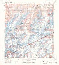
1954 Map of Mount McKinley A-2
USGS Topo · Published 1972About this map
Mt McKinley National Park is dominated by a massive glacial system in this mid-century survey, showcasing the high-altitude ice fields and sharp ridges that define the Alaska Range. The Muldrow Glacier flows through the northern reaches, fed by the Gunsight Pass and passing beneath McGonagall Mountain. Significant climbing landmarks are identified along the approach to the great peaks, including Karstens Ridge, Browne Tower, and Parker Pass. To the south, the landscape is defined by the sprawling Ruth Glacier and the wide Ruth Amphitheatre, which receive ice from the North Fork and Northwest Fork. The map records the precise positions of numerous summits such as Mount Silverthrone and Mount Deception, providing a high-resolution view of the terrain before later decades of glacial recession.
Find a feature on this map
50 named features on this map. Tap any name to fly to it.
Don’t see what you’re looking for? This feature index may not catch every label — zoom into the map to look around manually.
Map Details
Editions of this 1954 Mount McKinley A-2 Map
3 editions found
Other maps of this area

1950 · Talkeetna
USGS Topo · 1:250,000

1951 · Talkeetna
USGS Topo · 1:250,000

1952 · Mount McKinley
USGS Topo · 1:250,000

1952 · Mount McKinley B-2
USGS Topo · 1:63,360

1952 · Mount McKinley B-1
USGS Topo · 1:63,360

1953 · Mount McKinley B-3
USGS Topo · 1:63,360

1954 · Mount McKinley B-1
USGS Topo · 1:63,360

1954 · Mount McKinley B-3
USGS Topo · 1:63,360

1954 · Mount McKinley A-2
USGS Topo · 1:63,360

1954 · Mount McKinley A-3
USGS Topo · 1:63,360