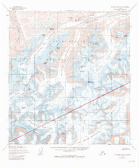
1954 Map of Mount McKinley A-2
USGS Topo · Published 1979About this map
Muldrow Glacier and its surrounding high-altitude ridges dominate this 1954 topographical survey, illustrating the complex glacial systems of Mount Mc Kinley National Park. The map documents the dramatic ice-carved topography including the Northwest Fork of the Ruth Glacier and the headwaters of the Traleika Glacier. Significant climbing landmarks are identified along Karstens Ridge, such as Browne Tower and Karstens Col, which represent critical points for high-altitude exploration and mountaineering history. The convergence of Carpe Ridge and Pioneer Ridge showcases the drainage patterns into the Peters Glacier, while the southeastern portion reveals the vast extent of the Eldridge Glacier. This survey captures the wilderness state of the Alaska Range before modern glacial retreat, marking specific summits like Mount Silverthrone and Mount Brooks.
Find a feature on this map
49 named features on this map. Tap any name to fly to it.
Don’t see what you’re looking for? This feature index may not catch every label — zoom into the map to look around manually.
Map Details
Editions of this 1954 Mount McKinley A-2 Map
3 editions found
Other maps of this area

1950 · Talkeetna
USGS Topo · 1:250,000

1951 · Talkeetna
USGS Topo · 1:250,000

1952 · Mount McKinley
USGS Topo · 1:250,000

1952 · Mount McKinley B-2
USGS Topo · 1:63,360

1952 · Mount McKinley B-1
USGS Topo · 1:63,360

1953 · Mount McKinley B-3
USGS Topo · 1:63,360

1954 · Mount McKinley B-1
USGS Topo · 1:63,360

1954 · Mount McKinley B-3
USGS Topo · 1:63,360

1954 · Mount McKinley A-2
USGS Topo · 1:63,360

1954 · Mount McKinley A-3
USGS Topo · 1:63,360