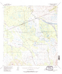
1954 Map of Mount McKinley B-3
USGS Topo · Published 1996About this map
Kantishna Hills dominate the northern landscape of this interior Alaskan territory, where the early 1950s survey captures a transition between high-altitude mining interests and protected wilderness. The presence of the Antimony Mine near the northern boundary, accessed via the Eldorado Trail and Slate Creek Trail, highlights the region's mineral history. Below the hills, the terrain flattens into a complex network of glacial waterways and wetlands. The McKinley River flows through the central valley, flanked by the McKinley Bar and the steep walls of Eagle Gorge. Large stretches of the Denali Wilderness are documented here, showing the intricate drainage patterns of Slippery Creek and McLeod Creek as they feed into the Muddy River. This map preserves the remote character of the park's backcountry before more modern infrastructure or shifting permafrost altered these riparian corridors.
Find a feature on this map
17 named features on this map. Tap any name to fly to it.
Don’t see what you’re looking for? This feature index may not catch every label — zoom into the map to look around manually.
Map Details
Editions of this 1954 Mount McKinley B-3 Map
5 editions found

Other maps of this area

1952 · Mount McKinley
USGS Topo · 1:250,000

1952 · Mount McKinley B-2
USGS Topo · 1:63,360

1952 · Mount McKinley C-3
USGS Topo · 1:63,360

1952 · Mount McKinley C-2
USGS Topo · 1:63,360

1953 · Mount McKinley B-4
USGS Topo · 1:63,360

1953 · Mount McKinley B-3
USGS Topo · 1:63,360

1953 · Mount McKinley C-4
USGS Topo · 1:63,360

1953 · Mount McKinley A-4
USGS Topo · 1:63,360

1954 · Mount McKinley C-4
USGS Topo · 1:63,360

1954 · Mount McKinley A-4
USGS Topo · 1:63,360