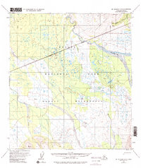
1954 Map of Mount McKinley B-3
USGS Topo · Published 1996About this map
The Kantishna Hills dominate the northeastern landscape of this mid-century survey, a region defined by its industrial mineral history and high-altitude drainage systems. Evidence of early resource extraction is preserved through the presence of the Antimony Mine and the winding Slate Creek Tractor Trail, which provided essential access through the terrain near Brooker Mtn. The hydrology of the area is complex, centered on the wide, braided course of the McKinley River and the Muddy River, which converge near the feature known as McKinley Bar.
Find a feature on this map
23 named features on this map. Tap any name to fly to it.
Don’t see what you’re looking for? This feature index may not catch every label — zoom into the map to look around manually.
Map Details
Editions of this 1954 Mount McKinley B-3 Map
5 editions found

Other maps of this area

1952 · Mount McKinley
USGS Topo · 1:250,000

1952 · Mount McKinley B-2
USGS Topo · 1:63,360

1952 · Mount McKinley C-3
USGS Topo · 1:63,360

1952 · Mount McKinley C-2
USGS Topo · 1:63,360

1953 · Mount McKinley B-4
USGS Topo · 1:63,360

1953 · Mount McKinley B-3
USGS Topo · 1:63,360

1953 · Mount McKinley C-4
USGS Topo · 1:63,360

1953 · Mount McKinley A-4
USGS Topo · 1:63,360

1954 · Mount McKinley C-4
USGS Topo · 1:63,360

1954 · Mount McKinley A-4
USGS Topo · 1:63,360