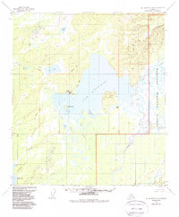
1953 Map of Mount McKinley D-5
USGS Topo · Published 1988About this map
Lake Minchumina dominates this interior Alaskan landscape, serving as a focal point for aviation and settlement. The Landing Strip and clusters of cabins along the shoreline indicate the importance of this water body for transport and seasonal residency. Several bays, including Giles Bay and New River Bay, break up the irregular coastline, while Moose Island and the prominent Yutokh Hill rise from the surrounding lowlands. The eastern portion of the sheet is defined by the expansive glacial drainages of the Foraker River and Muddy River, where the braided river channels flow toward the Denali National Preserve boundary. To the southwest, the Shisloiso Hills overlook North Snohomish Lake and Lake Snohomish, while a Winter Trail provides a overland route across the Parker Creek drainage and past Jim Lake.
Find a feature on this map
31 named features on this map. Tap any name to fly to it.
Don’t see what you’re looking for? This feature index may not catch every label — zoom into the map to look around manually.
Map Details
Editions of this 1953 Mount McKinley D-5 Map
2 editions found
Other maps of this area

1948 · Kantishna River
USGS Topo · 1:250,000

1951 · Kantishna River
USGS Topo · 1:250,000

1952 · Mount McKinley
USGS Topo · 1:250,000

1952 · Kantishna River
USGS Topo · 1:250,000

1952 · Kantishna River A-5
USGS Topo · 1:63,360

1952 · Kantishna River A-6
USGS Topo · 1:63,360

1953 · Mount McKinley C-5
USGS Topo · 1:63,360

1953 · Kantishna River A-4
USGS Topo · 1:63,360

1953 · Mount McKinley D-5
USGS Topo · 1:63,360

1953 · Mount McKinley C-4
USGS Topo · 1:63,360