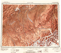
1952 Map of Mount McKinley
USGS Topo · Published 1954About this map
Mt McKinley and the massive Muldrow Glacier dominate this 1950s interior Alaska landscape, detailing a region defined by its monumental peaks and ice fields. In the northern reaches of Mt McKinley National Park, the map reveals early extraction sites like the Stampede Antimony Mine and Little Annie Mine, illustrating the territory's mid-century mining interests. Small settlements and landing areas such as Kantishna, Diamond, and Minchumina anchor the remote river systems, connected by an primitive network of trails and a designated Sled Road. The drainage patterns of the Kantishna River, Foraker River, and Swift Fork Kuskokwim River reveal the complex hydraulic geography between the Munsatli Mountains and the Alaska Range, where large bodies of water like Lake Minchumina and Wonder Lake provided critical landmarks for early bush pilots and explorers.
Find a feature on this map
45 named features on this map. Tap any name to fly to it.
Don’t see what you’re looking for? This feature index may not catch every label — zoom into the map to look around manually.
Map Details
Editions of this 1952 Mount McKinley Map
4 editions found

Other maps of this area

1948 · Kantishna River
USGS Topo · 1:250,000

1949 · McGrath
USGS Topo · 1:250,000

1949 · Talkeetna Mountains D-6
USGS Topo · 1:63,360

1949 · Healy A-6
USGS Topo · 1:63,360

1950 · Medfra
USGS Topo · 1:250,000

1950 · McGrath
USGS Topo · 1:250,000

1950 · Talkeetna Mountains
USGS Topo · 1:250,000

1950 · Talkeetna
USGS Topo · 1:250,000

1950 · Fairbanks
USGS Topo · 1:250,000

1951 · Talkeetna
USGS Topo · 1:250,000