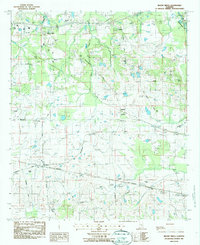
1987 Map of Mount Meigs
USGS Topo · Published 1987About this map
Mount Meigs serves as a primary hub for this portion of eastern Montgomery County during the late 1980s, where small settlements and family cemeteries are scattered across the landscape. The geography is defined by the drainage of Wallahatchee and Miller Creek, while the rural transport network is anchored by the CSX and Southern railroads. Local genealogy is well-represented through numerous burial grounds such as Antioch Cem, Mitchell Cem, and Judkins Cem, which often sit near established community centers like Waugh and McDade. Residential development is visible in emerging areas like Foxwood and along Old Pike Road, illustrating a transition from traditional agricultural patterns to suburban growth. Scattered Gravel pits indicate local extraction industries that operated alongside the region's historic crossroads, providing a detailed record of the physical and social structures of the period.
Find a feature on this map
50 named features on this map. Tap any name to fly to it.
Don’t see what you’re looking for? This feature index may not catch every label — zoom into the map to look around manually.
Map Details
Editions of this 1987 Mount Meigs Map
This is the sole edition of this map. No revisions or reprints were ever made.
Other maps of this area

1953 · Montgomery
USGS Topo · 1:250,000

1955 · Phenix City
USGS Topo · 1:250,000

1956 · Montgomery
USGS Topo · 1:250,000

1957 · Phenix City
USGS Topo · 1:250,000

1957 · Montgomery
USGS Topo · 1:250,000

1958 · Phenix City
USGS Topo · 1:250,000

1958 · Mount Meigs
USGS Topo · 1:62,500

1971 · Shorter
USGS Topo · 1:24,000
1971 · Fitzpatrick
USGS Topo · 1:24,000

1971 · Davis Crossroads
USGS Topo · 1:24,000