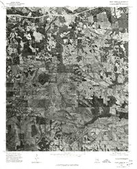
1975 Map of Mount Meigs SE
USGS Topo · Published 1977About this map
Mount Meigs and the surrounding central Alabama landscape are captured in this mid-1970s orthophotoquad, which uses aerial photography to detail the patchwork of fields and timberlands east of Montgomery. This specific format reveals the exact vegetation patterns and land use of the era, showing the transition from traditional agricultural plots to larger cleared tracts. The settlement of Waugh sits near the northern boundary, while Pike Road occupies the southwestern quadrant, illustrating the spread of rural communities along established thoroughfares. The inclusion of Mc Dade provides a precise look at these smaller unincorporated locales as they appeared before modern suburban expansion began to reshape the outskirts of the state capital. Unlike traditional line-drawn maps, this photographic survey allows researchers to see the actual farmstead structures and woodland boundaries that defined the rural South during this period.
Find a feature on this map
4 named features on this map. Tap any name to fly to it.
Don’t see what you’re looking for? This feature index may not catch every label — zoom into the map to look around manually.
Map Details
Editions of this 1975 Mount Meigs SE Map
This is the sole edition of this map. No revisions or reprints were ever made.
Other maps of this area

1953 · Montgomery
USGS Topo · 1:250,000

1955 · Phenix City
USGS Topo · 1:250,000

1956 · Montgomery
USGS Topo · 1:250,000

1957 · Phenix City
USGS Topo · 1:250,000

1957 · Montgomery
USGS Topo · 1:250,000

1958 · Phenix City
USGS Topo · 1:250,000

1958 · Mount Meigs
USGS Topo · 1:62,500

1971 · Shorter
USGS Topo · 1:24,000
1971 · Fitzpatrick
USGS Topo · 1:24,000

1971 · Davis Crossroads
USGS Topo · 1:24,000