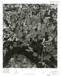
1975 Map of Mount Meigs SW
USGS Topo · Published 1977About this map
Agricultural fields and expanding residential pockets define this 1975 aerial view of the Alabama countryside east of Montgomery. The landscape is dominated by a transition from large-scale cultivation and timber tracts to the modern transport infrastructure of the mid-1970s. The most prominent corridor is the route of Interstate 85, which cuts through the northern portion of the quadrangle, serving as a primary artery for the region's suburban development. Below the interstate, the texture of the land reveals a complex pattern of woodlots, farm ponds, and winding local roads that hint at the area's rural roots before the intensification of highway-driven growth. This orthophotograph provides a precise visual record of land use and property boundaries during a period of significant change for the Montgomery area.
Find a feature on this map
1 named feature on this map. Tap any name to fly to it.
Don’t see what you’re looking for? This feature index may not catch every label — zoom into the map to look around manually.
Map Details
Editions of this 1975 Mount Meigs SW Map
This is the sole edition of this map. No revisions or reprints were ever made.
Other maps of this area

1927 · Montgomery
USGS Topo · 1:48,000

1930 · Montgomery
USGS Topo · 1:62,500

1953 · Montgomery
USGS Topo · 1:250,000

1956 · Montgomery
USGS Topo · 1:250,000

1957 · Montgomery
USGS Topo · 1:250,000

1957 · Letohatchee
USGS Topo · 1:62,500

1958 · Montgomery
USGS Topo · 1:62,500

1958 · Montgomery North
USGS Topo · 1:24,000

1958 · Montgomery South
USGS Topo · 1:24,000

1958 · Mount Meigs
USGS Topo · 1:62,500