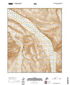
2018 Map of Mount Michelson B-5 NW
USGS Topo · Published 2018About this map
Juniper Cr and Fin Cr flow through this remote portion of the North Slope, draining a landscape defined by sharp elevation changes and high mountain ridgelines. Located in the eastern Brooks Range foothills, the terrain is divided by several township and range boundaries including t2n r21e, t1n r21e, and t1s r22e. The drainage patterns of these creeks suggest the complex hydrology of the Arctic wilderness before reaching the larger coastal plains to the north. This 2018 survey by the U.S. Geological Survey provides a precise look at the topographical contours of an area untouched by modern infrastructure, roads, or settlements, serving as a primary reference for the physical geography of the Mount Michelson region.
Find a feature on this map
8 named features on this map. Tap any name to fly to it.
Don’t see what you’re looking for? This feature index may not catch every label — zoom into the map to look around manually.
Map Details
Editions of this 2018 Mount Michelson B-5 NW Map
This is the sole edition of this map. No revisions or reprints were ever made.
Other maps of this area

1951 · Sagavanirktok D-5
USGS Topo · 1:250,000

1951 · Mt. Michelson
USGS Topo · 1:250,000

1955 · Mount Michelson C-5
USGS Topo · 1:63,360
1955 · Sagavanirktok C-1
USGS Topo · 1:63,360

1956 · Mt. Michelson
USGS Topo · 1:250,000

1956 · Sagavanirktok
USGS Topo · 1:250,000

1958 · Sagavanirktok
USGS Topo · 1:250,000

1964 · Sagavanirktok
USGS Topo · 1:250,000
1971 · Sagavanirktok B-1
USGS Topo · 1:63,360
1971 · Mount Michelson B-5
USGS Topo · 1:63,360