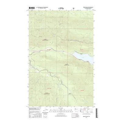
2017 Map of Mount Muller
USGS Topo · Published 2017About this map
Olympic National Park and Olympic National Forest converge in this high-elevation survey of Clallam County. The northern shoreline of Lake Crescent is a primary focal point, dominated by steep rises toward Pyramid Peak and Thompson Point. The hydrology of the area is defined by the complex headwaters of the Sol Duc River, with the North Fork and South Fork carving deep drainage patterns through the Olympic Mountains. Significant forest access is recorded through a network of service roads such as Nat For Dev Rd 3068 and the winding Sol Duc Hot Springs Rd. Historical land divisions are marked by numerous private boundary (PB) tracts, including PB 51 and PB 44, which sit adjacent to the prominent crest of Mount Muller. Local access points like Camp David Junior Rd provide transit to the lake's western edge near Meldrim Point.
Find a feature on this map
45 named features on this map. Tap any name to fly to it.
Don’t see what you’re looking for? This feature index may not catch every label — zoom into the map to look around manually.
Map Details
Editions of this 2017 Mount Muller Map
This is the sole edition of this map. No revisions or reprints were ever made.
Other maps of this area

1918 · Lake Crescent
USGS Topo · 1:62,500

1922 · Pysht
USGS Topo · 1:62,500

1922 · Lake Crescent
USGS Topo · 1:62,500

1939 · Mount Tom
USGS Topo · 1:62,500

1942 · Pysht
USGS Topo · 1:62,500

1943 · Spruce Mountain
USGS Topo · 1:62,500

1943 · Copalis Beach
USGS Topo · 1:250,000

1950 · Mount Muller
USGS Topo · 1:24,000

1950 · Twin Rivers
USGS Topo · 1:24,000
1950 · Disque
USGS Topo · 1:24,000