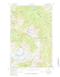
1956 Map of Mount Olympus
USGS Topo · Published 1983About this map
Olympic Hot Springs and high alpine glaciers define this mid-century survey of the Olympic Peninsula's interior. The landscape is dominated by the massive ice fields of Mount Olympus, including the Blue Glacier, Humes Glacier, and Carrie Glacier. Human presence is marked by isolated outposts such as Humes Ranch and Michaels Ranch along the Elwha River, alongside early infrastructure like the Hurricane Hill Lookout. The network of back-country trails and shelters, including Idaho Shelter and Lillian Shelter, illustrates the era's focus on wilderness management within Olympic National Park. The map also captures significant water features like Lake Mills and the dramatic passage at Goblins Gate, providing a detailed look at the hydrology of the Hoh River and Queets River headwaters before late-20th-century environmental shifts.
Find a feature on this map
67 named features on this map. Tap any name to fly to it.
Don’t see what you’re looking for? This feature index may not catch every label — zoom into the map to look around manually.
Map Details
Editions of this 1956 Mount Olympus Map
4 editions found

Other maps of this area

1918 · Port Angeles
USGS Topo · 1:62,500

1918 · Lake Crescent
USGS Topo · 1:62,500

1919 · Port Crescent
USGS Topo · 1:62,500

1922 · Lake Crescent
USGS Topo · 1:62,500

1935 · Mount Olympus
USGS Topo · 1:62,500

1938 · Mt Constance
USGS Topo · 1:125,000

1939 · Mount Tom
USGS Topo · 1:62,500

1941 · Port Angeles
USGS Topo · 1:62,500

1942 · Mount Olympus
USGS Topo · 1:62,500

1944 · Mt. Angeles
USGS Topo · 1:62,500