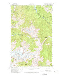
1956 Map of Mount Olympus
USGS Topo · Published 1974About this map
The crest of Mount Olympus dominates this mid-century survey of the high interior Olympics, where the Hoh River and Elwha River drainages diverge. The landscape is defined by massive glacial features like the Snow Dome and Blizzard Pass, which feed the river systems below. Evidence of early wilderness management and human activity appears in the network of remote shelters and family outposts, including Michaels Ranch and Humes Ranch along the Elwha. The presence of Lake Mills and the Hurricane Hill Lookout indicates the growing infrastructure for resource monitoring and early park visitation during the 1940s and 1950s.
Find a feature on this map
79 named features on this map. Tap any name to fly to it.
Don’t see what you’re looking for? This feature index may not catch every label — zoom into the map to look around manually.
Map Details
Editions of this 1956 Mount Olympus Map
4 editions found

Other maps of this area

1918 · Port Angeles
USGS Topo · 1:62,500

1918 · Lake Crescent
USGS Topo · 1:62,500

1919 · Port Crescent
USGS Topo · 1:62,500

1922 · Lake Crescent
USGS Topo · 1:62,500

1935 · Mount Olympus
USGS Topo · 1:62,500

1938 · Mt Constance
USGS Topo · 1:125,000

1939 · Mount Tom
USGS Topo · 1:62,500

1941 · Port Angeles
USGS Topo · 1:62,500

1942 · Mount Olympus
USGS Topo · 1:62,500

1944 · Mt. Angeles
USGS Topo · 1:62,500