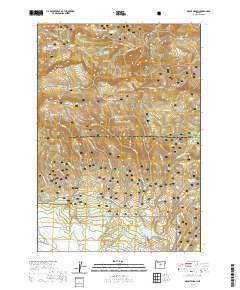
2020 Map of Mount Pisgah
USGS Topo · Published 2020About this map
Mt Pisgah and the high ridges of the Ochoco National Forest dominate this high-altitude landscape along the border of Wheeler and Crook counties. This modern survey illustrates a terrain defined by its water sources and seasonal access, where numerous named springs such as Nelson Spring, Pisgah Spring, and Milk Spring sustain the headwaters of creeks like Maxwell Cr and Bridge Cr. The presence of Snomobile #2 (Snow) and Snomobile #3 (Snow) trails suggests the area's primary use for winter recreation and forestry management.
Find a feature on this map
50 named features on this map. Tap any name to fly to it.
Don’t see what you’re looking for? This feature index may not catch every label — zoom into the map to look around manually.
Map Details
Editions of this 2020 Mount Pisgah Map
This is the sole edition of this map. No revisions or reprints were ever made.
Other maps of this area

1926 · Mitchell
USGS Topo · 1:125,000

1951 · Lookout Mtn
USGS Topo · 1:62,500

1955 · Bend
USGS Topo · 1:250,000

1957 · Bend
USGS Topo · 1:250,000

1958 · Bend
USGS Topo · 1:250,000

1965 · Williams Prairie
USGS Topo · 1:24,000

1966 · Keys Creek
USGS Topo · 1:24,000

1966 · Peterson Point
USGS Topo · 1:24,000

1966 · Mt. Pisgah
USGS Topo · 1:24,000

1966 · Mitchell
USGS Topo · 1:62,500