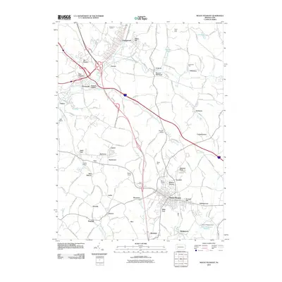
2010 Map of Mount Pleasant
USGS Topo · Published 2010About this map
Mount Pleasant serves as a significant hub in this Westmoreland County landscape, showing the dense residential patterns of Ramsay Terrace and Orchard Hill. The area's industrial and coal heritage is evidenced by place names like Standard Shaft and Carpentertown, while the intersection of major thoroughfares at New Stanton highlights the region's role in Pennsylvania's modern transportation network. North of the borough, the terrain is shaped by the winding course of Sewickley Creek and its tributaries, including Wilson Run and Jacks Run. Smaller communities and named clusters like Weavers Old Stand, Tarrs, and Armbrust dot the countryside, providing a detailed look at the rural-to-suburban transition. For those tracing family histories, the inclusion of Youngwood Cemetery, Polish Cemetery, and Mount Pleasant Cemetery offers precise locations for local genealogical research.
Find a feature on this map
132 named features on this map. Tap any name to fly to it.
Don’t see what you’re looking for? This feature index may not catch every label — zoom into the map to look around manually.
Map Details
Editions of this 2010 Mount Pleasant Map
This is the sole edition of this map. No revisions or reprints were ever made.
Other maps of this area

1900 · Latrobe
USGS Topo · 1:62,500

1902 · Latrobe
USGS Topo · 1:62,500

1902 · Connellsville
USGS Topo · 1:62,500

1903 · Latrobe
USGS Topo · 1:62,500

1904 · Greensburg
USGS Topo · 1:62,500

1906 · Greensburg
USGS Topo · 1:62,500

1922 · Donegal
USGS Topo · 1:62,500

1931 · Connellsville
USGS Topo · 1:62,500

1935 · Donegal
USGS Topo · 1:62,500

1936 · Connellsville
USGS Topo · 1:62,500