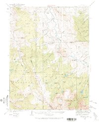
1933 Map of Mount Powell
USGS Topo · Published 1965About this map
The Gore Range and Williams Fork Mountains dominate this high-altitude landscape as surveyed in the early 1930s. Centered on the confluence of the Blue River and the Colorado River, the map reveals a remote ranching and homesteading network before modern development. Notable educational outposts like Hillcrest Sch and Upper Sheephorn Sch served the scattered families living at Noonan Ranch, Doenz Place, and Abbet Place. The drainages of Noonan Creek and Spruce Creek carve through the terrain, while the high country is punctuated by glacial features such as Lower Cataract Lake and Mirror Lake. The presence of Lakeside Hall and the settlement of Sheephorn suggests small localized community centers tucked between the ridges of the Arapaho National Forest.
Find a feature on this map
80 named features on this map. Tap any name to fly to it.
Don’t see what you’re looking for? This feature index may not catch every label — zoom into the map to look around manually.
Map Details
Editions of this 1933 Mount Powell Map
5 editions found
Other maps of this area

1929 · Dillon
USGS Topo · 1:62,500

1933 · Mt. Powell
USGS Topo · 1:48,000

1933 · Ute Peak
USGS Topo · 1:62,500

1934 · Minturn
USGS Topo · 1:62,500

1934 · Dillon
USGS Topo · 1:62,500

1937 · Ute Peak
USGS Topo · 1:62,500

1940 · Mount Powell
USGS Topo · 1:62,500

1950 · Minturn
USGS Topo · 1:62,500

1954 · Craig
USGS Topo · 1:250,000

1956 · Kremmling
USGS Topo · 1:62,500