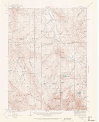
1933 Map of Mount Powell
USGS Topo · Published 1965About this map
Mt Powell and the high peaks of the Gore Range dominate this 1930s survey, marking a time when the high country of Summit, Eagle, and Grand Counties was defined by isolated ranching outposts and high-altitude water sources. The Blue River cuts a central path through the terrain, serving as a primary corridor for early development including the Hillcrest Sch and the community gathering point at Lakeside Hall.
Find a feature on this map
75 named features on this map. Tap any name to fly to it.
Don’t see what you’re looking for? This feature index may not catch every label — zoom into the map to look around manually.
Map Details
Editions of this 1933 Mount Powell Map
5 editions found
Other maps of this area

1929 · Dillon
USGS Topo · 1:62,500

1933 · Mt. Powell
USGS Topo · 1:48,000

1933 · Ute Peak
USGS Topo · 1:62,500

1934 · Minturn
USGS Topo · 1:62,500

1934 · Dillon
USGS Topo · 1:62,500

1937 · Ute Peak
USGS Topo · 1:62,500

1940 · Mount Powell
USGS Topo · 1:62,500

1950 · Minturn
USGS Topo · 1:62,500

1954 · Craig
USGS Topo · 1:250,000

1956 · Kremmling
USGS Topo · 1:62,500