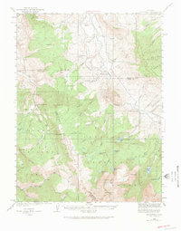
1933 Map of Mount Powell
USGS Topo · Published 1974About this map
Mt Powell stands as the dramatic centerpiece of this high-altitude survey, marking the intersection where the Gore Range and Williams Fork Mountains converge. The landscape is defined by its dramatic hydrology, featuring a dense network of alpine water bodies including Lower Cataract Lake, Surprise Lake, and Mahan Lake. These waters drain through rugged canyons like Cataract Creek and Slate Creek, which carve through the Arapaho National Forest and White River National Forest.
Find a feature on this map
71 named features on this map. Tap any name to fly to it.
Don’t see what you’re looking for? This feature index may not catch every label — zoom into the map to look around manually.
Map Details
Editions of this 1933 Mount Powell Map
5 editions found
Other maps of this area

1929 · Dillon
USGS Topo · 1:62,500

1933 · Mt. Powell
USGS Topo · 1:48,000

1933 · Ute Peak
USGS Topo · 1:62,500

1934 · Minturn
USGS Topo · 1:62,500

1934 · Dillon
USGS Topo · 1:62,500

1937 · Ute Peak
USGS Topo · 1:62,500

1940 · Mount Powell
USGS Topo · 1:62,500

1950 · Minturn
USGS Topo · 1:62,500

1954 · Craig
USGS Topo · 1:250,000

1956 · Kremmling
USGS Topo · 1:62,500