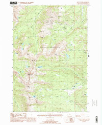
1988 Map of Mount Tahepia
USGS Topo · Published 1988About this map
Mining operations and alpine hydrology define this section of the Beaverhead National Forest in the late 1980s. High-elevation extraction sites concentrated around Sheriff Mountain and Lion Mountain include the Hecla Mines, Cleve Mine, and Franklin Mine, while scattered shafts and adits indicate a landscape thoroughly prospected for its mineral wealth. This industrial activity exists alongside a network of high-country lakes, with Tahepia Lake and Waukena Lake situated just below the dramatic peaks of Mount Tahepia and Mount Alverson.
Find a feature on this map
47 named features on this map. Tap any name to fly to it.
Don’t see what you’re looking for? This feature index may not catch every label — zoom into the map to look around manually.
Map Details
Editions of this 1988 Mount Tahepia Map
2 editions found
Other maps of this area

1893 · Dillon
USGS Topo · 1:250,000

1952 · Twin Adams Mountain
USGS Topo · 1:24,000

1952 · Torrey Mountain
USGS Topo · 1:24,000

1955 · Dillon
USGS Topo · 1:250,000

1957 · Dillon
USGS Topo · 1:250,000

1958 · Dillon
USGS Topo · 1:250,000

1958 · Vipond Park
USGS Topo · 1:62,500

1959 · Polaris
USGS Topo · 1:62,500

1962 · Dillon
USGS Topo · 1:250,000

1965 · Dillon
USGS Topo · 1:250,000