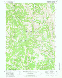
1980 Map of Mount Wagner
USGS Topo · Published 1980About this map
The Emigrant Trail (Lander Cutoff) traces the southwestern edge of this landscape, marking a significant historical corridor for westward expansion through the Wyoming high country. This 1980 survey by the Geological Survey documents a network of primitive access points within the Bridger National Forest, where steep drainages such as Mud Gulch and Cedar Creek feed into the upper reaches of the Salt River. The topography is dominated by the prominence of Mount Wagner, with localized water features including Wagner Lake and Slide Lake providing critical points of reference for those navigating the backcountry.
Find a feature on this map
21 named features on this map. Tap any name to fly to it.
Don’t see what you’re looking for? This feature index may not catch every label — zoom into the map to look around manually.
Map Details
Editions of this 1980 Mount Wagner Map
This is the sole edition of this map. No revisions or reprints were ever made.
Other maps of this area

1921 · Afton
USGS Topo · 1:125,000

1936 · Cokeville
USGS Topo · 1:96,000

1942 · Cokeville
USGS Topo · 1:125,000

1955 · Preston
USGS Topo · 1:250,000

1958 · Preston
USGS Topo · 1:250,000

1962 · Preston
USGS Topo · 1:250,000

1967 · Graham Peak
USGS Topo · 1:24,000

1967 · Porcupine Creek
USGS Topo · 1:24,000
1967 · Salt Flat
USGS Topo · 1:24,000
1980 · Smoot
USGS Topo · 1:24,000