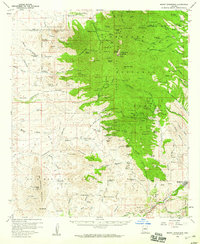
1958 Map of Mount Wrightson
USGS Topo · Published 1959About this map
The Santa Rita Mountains dominate this late 1950s survey of southern Arizona, showcasing a landscape defined by its mining heritage and cattle ranching. High peaks such as Mt Wrightson and Josephine Peak overlook a terrain carved by Agua Caliente Canyon and Temporal Gulch, where numerous shafts and tunnels mark the search for minerals. The mining industry is heavily documented here, with names like the Glove Mine, Eureka Mine, and the Wandering Jew Group appearing alongside the Southern Pacific Railroad corridor in the southeast.
Find a feature on this map
153 named features on this map. Tap any name to fly to it.
Don’t see what you’re looking for? This feature index may not catch every label — zoom into the map to look around manually.
Map Details
Editions of this 1958 Mount Wrightson Map
4 editions found
Other maps of this area

1904 · Patagonia
USGS Topo · 1:125,000

1905 · Patagonia
USGS Topo · 1:125,000

1905 · Nogales
USGS Topo · 1:125,000

1920 · Arivaca
USGS Topo · 1:125,000

1921 · Old Glory
USGS Topo · 1:125,000

1922 · Agus Caliente
USGS Topo · 1:62,500

1925 · Samaniego Peak
USGS Topo · 1:62,500

1926 · Helvetia
USGS Topo · 1:62,500

1932 · Lochiel
USGS Topo · 1:62,500

1932 · Elgin
USGS Topo · 1:62,500