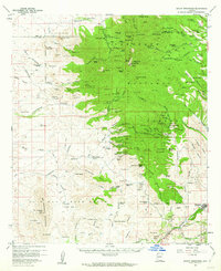
1958 Map of Mount Wrightson
USGS Topo · Published 1962About this map
Coronado National Forest dominates this mid-century view of the Santa Rita Mountains, where the landscape is etched with the remnants of late-19th and early-20th-century mining efforts. The map documents the scattered Alto (Site) and several historic cattle operations like Salero Ranch and Weatherhead Ranch. Mineral exploration is represented by an extensive network of claims including the Helvetia Mine, Eureka Mine, and the Montosa Mine, many of which were accessed by rugged jeep trails. The southern portion of the quadrangle shows the distinctive Luis Maria Baca Grant (Float No 3), a significant Spanish land grant legacy. Transportation and cultural history are marked by the San Jose Railroad Grade and a petroglyph near the San Cayetano Mountains, indicating centuries of human presence from indigenous peoples to railroad engineers.
Find a feature on this map
147 named features on this map. Tap any name to fly to it.
Don’t see what you’re looking for? This feature index may not catch every label — zoom into the map to look around manually.
Map Details
Editions of this 1958 Mount Wrightson Map
4 editions found
Other maps of this area

1904 · Patagonia
USGS Topo · 1:125,000

1905 · Patagonia
USGS Topo · 1:125,000

1905 · Nogales
USGS Topo · 1:125,000

1920 · Arivaca
USGS Topo · 1:125,000

1921 · Old Glory
USGS Topo · 1:125,000

1922 · Agus Caliente
USGS Topo · 1:62,500

1925 · Samaniego Peak
USGS Topo · 1:62,500

1926 · Helvetia
USGS Topo · 1:62,500

1932 · Lochiel
USGS Topo · 1:62,500

1932 · Elgin
USGS Topo · 1:62,500