1966 Map of Mountain Home West
USGS Topo · Published 1967About this map
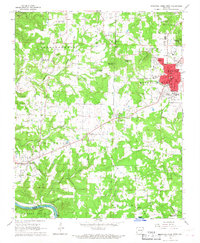
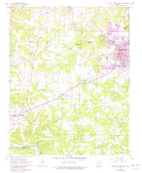
Mountain Home serves as the focal point of this mid-1960s Ozark landscape, shown just as the town was expanding westward. The map reveals a dense network of civic and religious institutions, from the Courthouse and Post Office in the center of town to rural landmarks like Westside Ch and Whiteville Ch. The western half of the quadrangle is defined by the rugged drainage of Lithia Creek, Hightower Creek, and Keefer Creek, where small settlements like Monkey Run and Colfax sit along the ridges. Evidence of local infrastructure is prominent, including the Twin Lakes Municipal Airport and several localized quarries and gravel pits. To the south, the White River and Crooked Creek border the rugged terrain of Buford, illustrating the transition from the plateau's developed settlements to the river-carved valleys of the Arkansas Highlands.
Find a feature on this map
55 named features on this map. Tap any name to fly to it.
Don’t see what you’re looking for? This feature index may not catch every label — zoom into the map to look around manually.
Map Details
Editions of this 1966 Mountain Home West Map
2 editions found
Other maps of this area

1890 · Mountain Home
USGS Topo · 1:125,000

1891 · Mountain Home
USGS Topo · 1:125,000

1893 · Yellville
USGS Topo · 1:125,000

1894 · Mountain Home
USGS Topo · 1:125,000

1903 · Yellville
USGS Topo · 1:125,000

1905 · Yellville
USGS Topo · 1:125,000

1929 · Yellville
USGS Topo · 1:125,000

1945 · Harrison
USGS Topo · 1:250,000

1949 · Harrison
USGS Topo · 1:250,000

1954 · Harrison
USGS Topo · 1:250,000