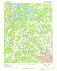
1969 Map of Mountain Island Lake
USGS Topo · Published 1973About this map
Mountain Island Lake dominates the northern landscape of this survey, defining the border between Gaston and Mecklenburg counties. The area showcases a mid-century transition from rural outposts like Shuffletown and Paw Creek toward the expanding industrial and suburban footprint of Charlotte. Infrastructure for the growing region is evident in the presence of the Powerplant near Mountain Island and the Filtration Plant at the Charlotte Reservoir. Local history is preserved through numerous family-named landmarks and rural institutions, including Cooke Memorial Cemetery and the Hopewell School. The Seaboard Coast Line railroad cuts through the southern half of the map, serving industrial zones like Chemway and Sodyeco, while residential developments begin to cluster around Toddville and Homestead. This period of development also features established social sites like the numerous golf courses and Beatties Ford Memorial Gardens.
Find a feature on this map
73 named features on this map. Tap any name to fly to it.
Don’t see what you’re looking for? This feature index may not catch every label — zoom into the map to look around manually.
Map Details
Editions of this 1969 Mountain Island Lake Map
2 editions found
Other maps of this area

1905 · Charlotte
USGS Topo · 1:48,000

1907 · Charlotte
USGS Topo · 1:62,500

1914 · Gastonia
USGS Topo · 1:48,000

1916 · Gastonia
USGS Topo · 1:62,500

1941 · Charlotte
USGS Topo · 1:125,000

1942 · Charlotte
USGS Topo · 1:125,000

1947 · Clover
USGS Topo · 1:62,500

1948 · Paw Creek
USGS Topo · 1:24,000

1948 · Derita
USGS Topo · 1:24,000

1948 · Charlotte East
USGS Topo · 1:24,000