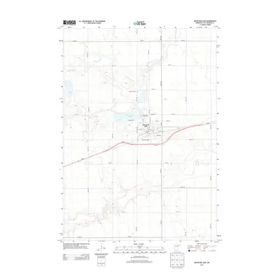
2013 Map of Mountain Lake
USGS Topo · Published 2013About this map
Mountain Lake serves as the focal point of this Cottonwood County survey, where the town site is bounded by the eponymous Mountain Lake and the meandering path of the Watonwan River. The settlement pattern is defined by a dense grid of residential streets like 9th Ave and 3rd Ave south of the shoreline, transitioning into a vast checkerboard of agricultural sections. The local heritage is preserved in sites such as the Mennonite Cem north of the lake and the Saint John's Lutheran Cem, reflecting the area's religious and communal foundations. Essential services are concentrated in the town center near the Po, while transportation is dominated by the MN-60 corridor and a network of county roads including Co HWY-1 that connect this prairie community to the surrounding farmland.
Find a feature on this map
39 named features on this map. Tap any name to fly to it.
Don’t see what you’re looking for? This feature index may not catch every label — zoom into the map to look around manually.
Map Details
Editions of this 2013 Mountain Lake Map
This is the sole edition of this map. No revisions or reprints were ever made.
Other maps of this area

1953 · New Ulm
USGS Topo · 1:250,000

1954 · Fairmont
USGS Topo · 1:250,000

1957 · New Ulm
USGS Topo · 1:250,000

1958 · New Ulm
USGS Topo · 1:250,000

1958 · Fairmont
USGS Topo · 1:250,000

1967 · New Ulm
USGS Topo · 1:250,000

1967 · Sanborn SE
USGS Topo · 1:24,000

1967 · Darfur
USGS Topo · 1:24,000
1967 · Comfrey
USGS Topo · 1:24,000
1970 · Butterfield
USGS Topo · 1:24,000