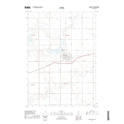
2019 Map of Mountain Lake
USGS Topo · Published 2019About this map
Mountain Lake serves as the focal point for this Cottonwood County landscape, situated on the southern shore of its namesake water body. The street grid of the city is clearly defined by residential avenues ranging from 1st Ave to 6th Ave, intersected by streets such as Prince St and Box Elder St. This modern survey illustrates the proximity of the town to its agricultural surroundings and water resources, including the Watonwan River which meanders through the northern sections of the township. Local heritage is grounded in the presence of the Mennonite Cem and Saint John's Lutheran Cem, both situated just north of the city center near Midway Rd. To the west, the landscape is punctuated by Long Lake, while the region's transport network is defined by a dense grid of county roads including Co Rd 9 and Co Hwy 16.
Find a feature on this map
34 named features on this map. Tap any name to fly to it.
Don’t see what you’re looking for? This feature index may not catch every label — zoom into the map to look around manually.
Map Details
Editions of this 2019 Mountain Lake Map
This is the sole edition of this map. No revisions or reprints were ever made.
Other maps of this area

1953 · New Ulm
USGS Topo · 1:250,000

1954 · Fairmont
USGS Topo · 1:250,000

1957 · New Ulm
USGS Topo · 1:250,000

1958 · New Ulm
USGS Topo · 1:250,000

1958 · Fairmont
USGS Topo · 1:250,000

1967 · New Ulm
USGS Topo · 1:250,000

1967 · Sanborn SE
USGS Topo · 1:24,000

1967 · Darfur
USGS Topo · 1:24,000
1967 · Comfrey
USGS Topo · 1:24,000
1970 · Butterfield
USGS Topo · 1:24,000