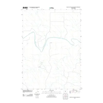
2012 Map of Mouth of Little Dog Creek
USGS Topo · Published 2012About this map
The White River winds through this section of Mellette County, creating a series of deep meanders that define the local geography. This high-plains landscape is characterized by its drainage network, where the Little Dog Cr and Sedlano Cr flow toward the main river valley. Human presence is represented by established agricultural operations, specifically Krutson Ranch and Iverson Ranch, which are situated near the junction of secondary roads and smaller tributaries like Oak Cr. The map's contour lines illustrate the elevation changes between the river basin and the surrounding prairie, reflecting a rural South Dakota environment centered on cattle ranching and waterway access in the early 21st century.
Find a feature on this map
6 named features on this map. Tap any name to fly to it.
Don’t see what you’re looking for? This feature index may not catch every label — zoom into the map to look around manually.
Map Details
Editions of this 2012 Mouth of Little Dog Creek Map
This is the sole edition of this map. No revisions or reprints were ever made.
Other maps of this area

1951 · Badnation
USGS Topo · 1:24,000

1951 · Presho 4 NE
USGS Topo · 1:24,000

1951 · Presho 4 NW
USGS Topo · 1:24,000

1955 · Martin
USGS Topo · 1:250,000

1958 · Martin
USGS Topo · 1:250,000

1972 · Vivian SE
USGS Topo · 1:24,000
1978 · Presho SE
USGS Topo · 1:24,000

1978 · Presho SW
USGS Topo · 1:24,000

1982 · Presho 4 SE
USGS Topo · 1:25,000

1982 · Two Nation Creek
USGS Topo · 1:25,000