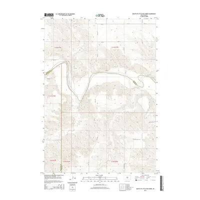
2015 Map of Mouth of Little Dog Creek
USGS Topo · Published 2015About this map
The White River carves a winding path through this portion of South Dakota, serving as a natural boundary between Lyman, Mellette, and Tripp counties. This 2015 survey reveals a landscape defined by its watercourses and prominent topographic features, most notably the Pahapesto Buttes in the southeast. Smaller tributaries such as Little Dog Cr, Oak Cr, and Sedlano Cr drain the surrounding terrain, which is primarily navigated via a grid of rural routes including Pahapesto Buttes Rd and Pumpkin Rd. The map illustrates the convergence of multiple townships and ranges, where the intersection of Lyman, Mellette, and Tripp county lines underscores the complex administrative geography of this prairie region.
Find a feature on this map
24 named features on this map. Tap any name to fly to it.
Don’t see what you’re looking for? This feature index may not catch every label — zoom into the map to look around manually.
Map Details
Editions of this 2015 Mouth of Little Dog Creek Map
This is the sole edition of this map. No revisions or reprints were ever made.
Other maps of this area

1951 · Badnation
USGS Topo · 1:24,000

1951 · Presho 4 NE
USGS Topo · 1:24,000

1951 · Presho 4 NW
USGS Topo · 1:24,000

1955 · Martin
USGS Topo · 1:250,000

1958 · Martin
USGS Topo · 1:250,000

1972 · Vivian SE
USGS Topo · 1:24,000
1978 · Presho SE
USGS Topo · 1:24,000

1978 · Presho SW
USGS Topo · 1:24,000

1982 · Presho 4 SE
USGS Topo · 1:25,000

1982 · Two Nation Creek
USGS Topo · 1:25,000